Categories
Notes from the field

Notes from the Field: Beaufort, North Carolina, USA

A very Happy 2015 to all our readers. To kick off the new year, we bring you a new segment of notes from the field, this time from the USA, where Amy Uhrin writes about the research work going on in the eelgrass beds of Beaufort, North Carolina. Amy is a Research Ecologist with the National Oceanic and Atmospheric Administration (NOAA). Her research focuses on the influence of natural physical disturbances (e.g., hurricanes, wind waves, tidal currents) and human-influenced disturbances (e.g., vessel groundings, fishing gear) on seagrass seascapes and how seagrass spatial configuration may serve as an indicator of system vulnerability and resilience. Amy is also a PhD candidate in the Ecosystem and Landscape Ecology Lab of Dr. Monica Turner at the University of Wisconsin-Madison.

Text and photos by Amy V. Uhrin

—————————————————-

The Albemarle-Pamlico Sound Estuary System in North Carolina is the second largest estuary in the United States. The Albemarle-Pamlico Sound Estuary System is a coastal lagoon bordered on the east and south by a chain of barrier islands (Outer Banks). Broad shallows, less than 2-meters deep at mean lower low water, are punctuated by relatively few deeper basins and channels. Seagrass beds along this portion of the North Carolina coast cover ~7000 hectares in a nearly continuous, ~1 km swath behind the extensive barrier island system.

IMG_0508.JPG
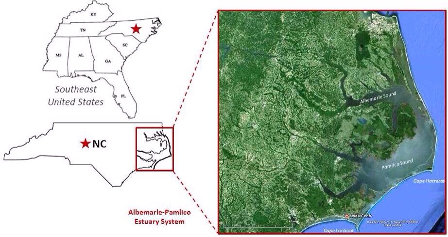
Figure 1 – The location of the Albemarle-Pamlico Sound Estuary System relative to the State of North Carolina and the southeastern United States.

The beds are dominated by a mixture of two species, Zostera marina (eelgrass) and Halodule wrightii (shoalgrass), with seasonally abundant Ruppia maritima (widgeongrass) in quiescent areas. This region represents the southern geographic limit of Z. marina and the northern geographic limit of H. wrightii on the east coast of North America and is the only known overlapping acreage of these two species in the world. H. wrightii has higher tolerances to fluctuations in light and water temperature than Z. marina, and so it has been suggested that the Albemarle-Pamlico Sound Estuary System could revert to a Halodule-dominated system over time as a result of climate change (i.e., increasing water temperature and sea level rise). Therefore, we have embarked on a field study to evaluate changes in the seagrass community (shoot density, biomass, species composition) over the last 20+ years.

IMG_0509.JPG
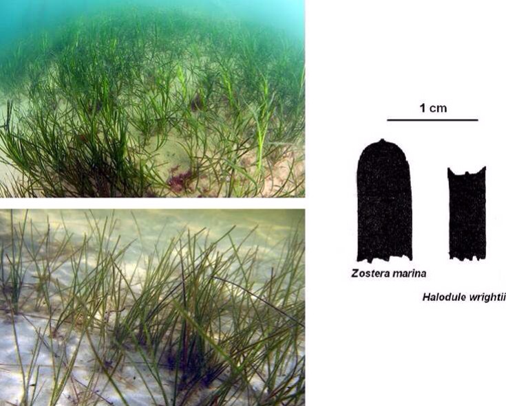
Figure 2 – Zostera marina (top) and Halodule wrightii (bottom). Visually, the two species appear very similar (strap-like blades) but are easily distinguished by their differing blades tips, blade widths, and rhizome structures.

The field study involves sampling at 10 historic study sites which were thoroughly evaluated in 1992 by staff here at NOAA’s Center for Coastal Fisheries and Habitat Research (CCFHR) in Beaufort, North Carolina. The 10 sites exist along an increasing gradient of tidal current speed and wind-wave exposure which results in seagrass seascapes ranging from continuous meadows (extending tens of kilometers) to aggregations of patchy mounds (less than a meter across).

IMG_0510.JPG
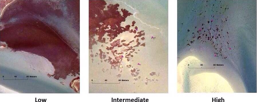
Figure 3 – Seagrass seascapes in coastal North Carolina range from continuous meadows to patchy seagrass as a result of increasing hydrodynamic stress.

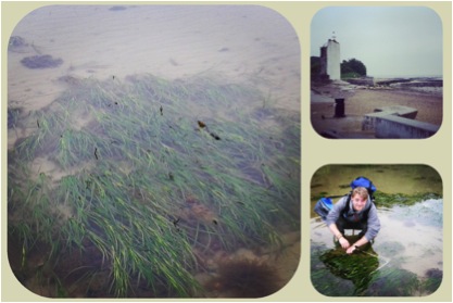
The project was initiated in 2013. This past spring and summer we collected our second set of field data. Because the two seagrass species achieve peak biomass at different times of the year, we must sample in late May to early June for Z. marina and again in late August to early September for H. wrightii. The patchy sites are mapped by physically tracing the perimeters of all seagrass patches located within a 50 x 100 meter area using a handheld GPS unit.

IMG_0511.JPG
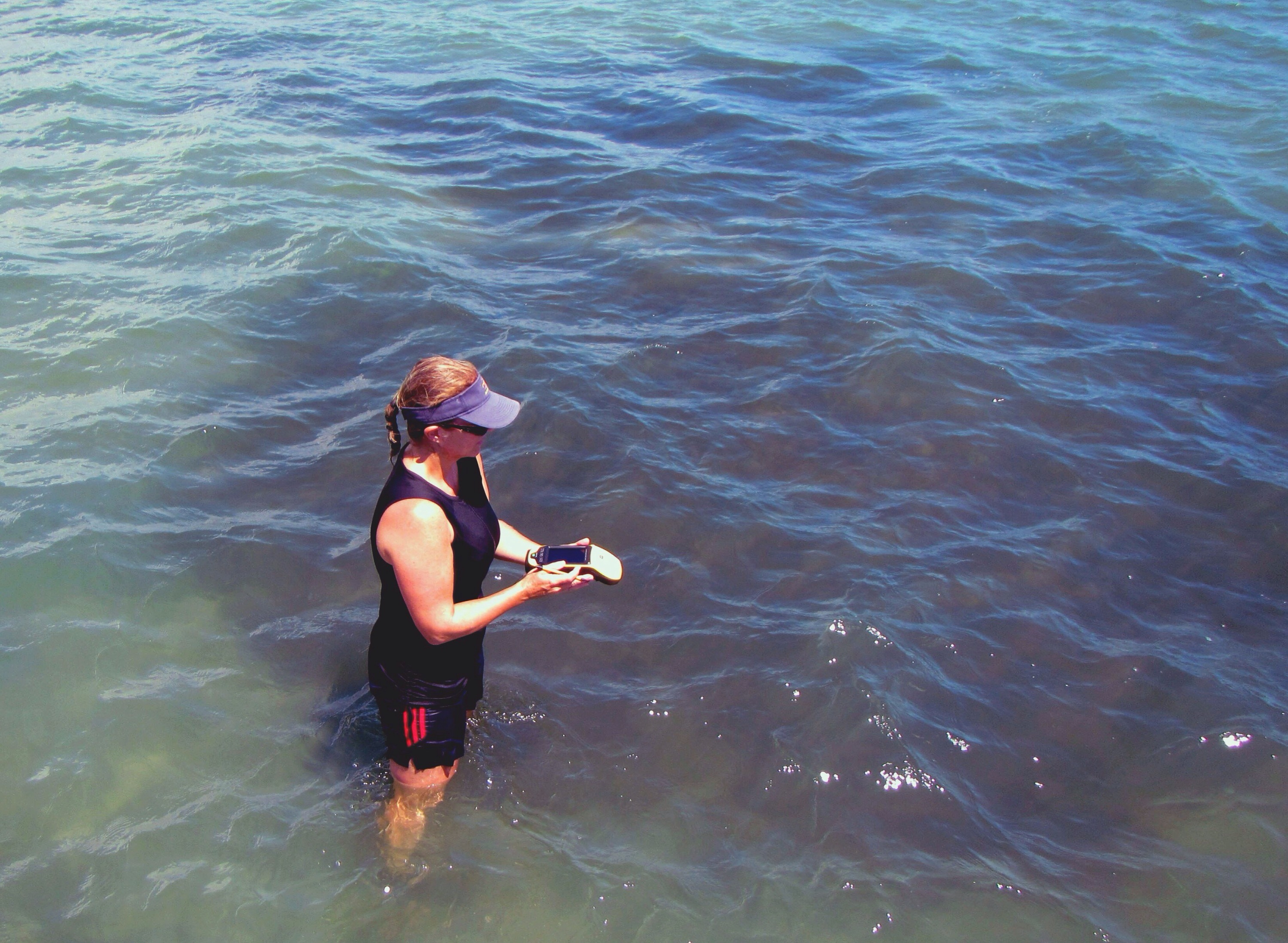
Figure 4 – Here, lead PI Amy Uhrin traces the perimeter of a seagrass patch using a handheld GPS unit.

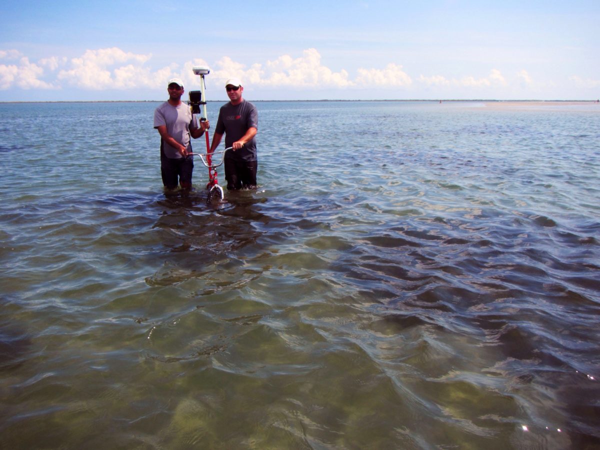
We also conducted elevation surveys at patchy sites using Real Time Kinematic (RTK) GPS. The elevation surveys require that an off-site GPS base receiver station is established within 5 kilometers of the study site in conjunction with an existing local reference benchmark (a geographic point whose coordinates and/or elevation has been measured and recorded to a high level of accuracy). The benchmark is linked to a local tidal datum using NGS VDatum utility. The local tidal datum is then used as a reference to measure local water levels. The GPS errors calculated at the reference base station are radio broadcast to the GPS rover receiver being used at the study site. The rover receiver also collects its own set of coordinates which are then corrected on the fly relative to the reference benchmark. After post-processing, this results in a submerged, topographic map of the seagrass patches with centimeter-level vertical accuracy.

IMG_0512.JPG
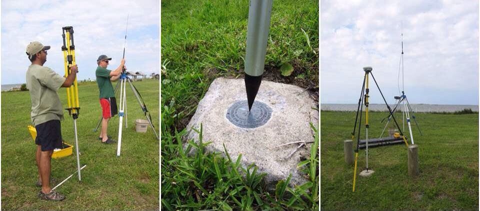
Figure 5 – CCFHR staff Amit Malhotra and Don Field install the off-site base station and radio antenna (left). The base station antenna is positioned directly over the existing GPS benchmark (middle). The final antenna arrangement is shown in the photo at the right.

A key limitation of conducting surveys via RTK GPS is that the antenna for the rover receiver must be in contact with the surface of the substrate at all times because coordinates are collected continuously at one-second intervals. For our surveys, we adopted an innovative technique that developed at our lab for use in salt marsh elevation surveys where the GPS antenna for the rover receiver is mounted to a bicycle that is manually maneuvered by hand across the study site following a grid pattern to ensure far-reaching coverage of data points.

IMG_0513.JPG
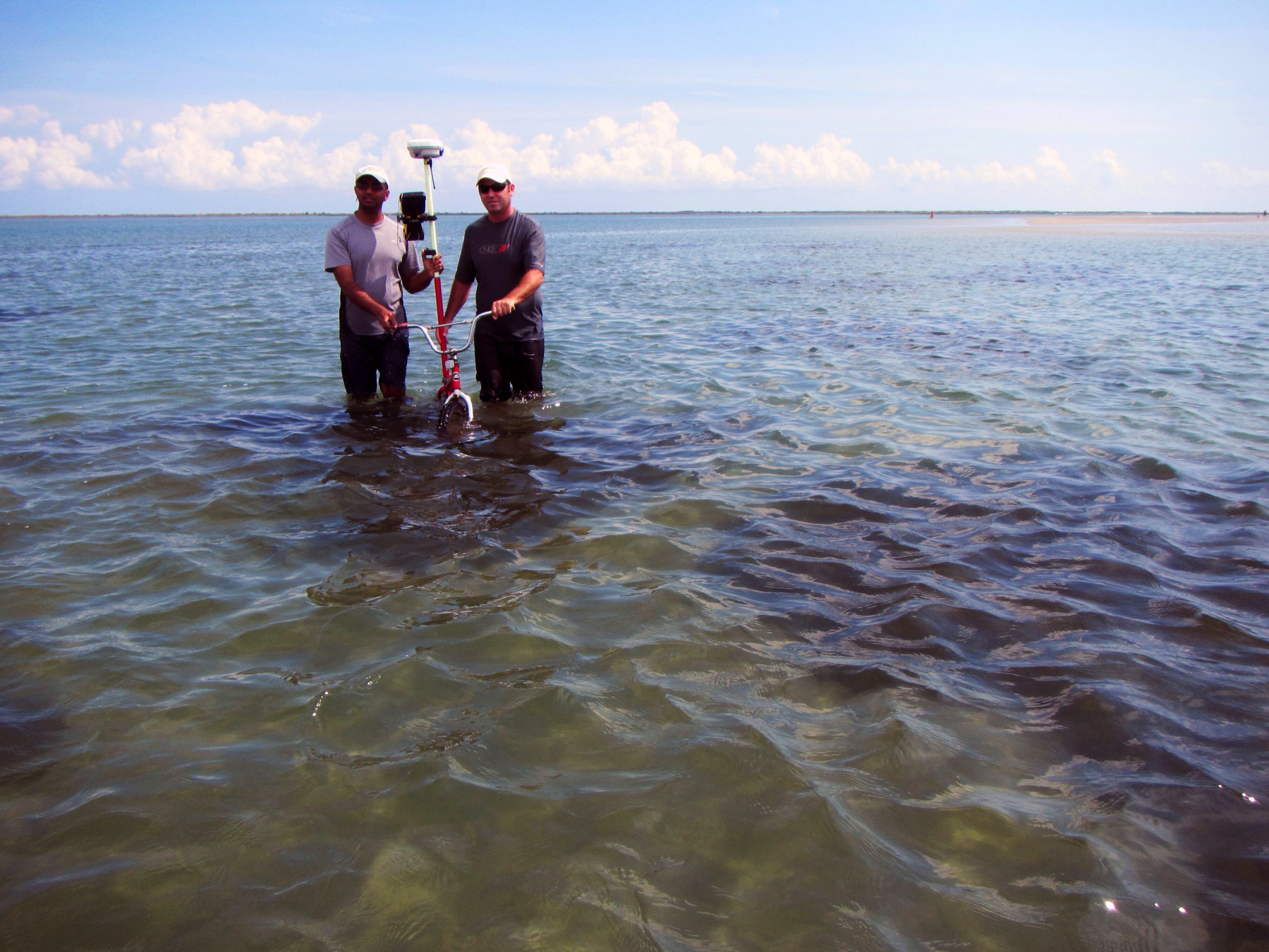
Figure 6 – CCFHR staff Amit Malhotra and Troy Rezek maneuver the bicycle with attached antenna across seagrass patches at one of our study sites.

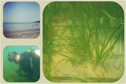
In addition to mapping, we performed Braun-Blanquet estimates of percent cover and extract core samples for measuring shoot density, leaf lengths, and above- and belowground biomass and for determination of species composition at all sites. Water depth is variable at the sites which can create a sampling challenge. Although it is easier to extract cores in shallow water, estimating percent cover is not as easy when plants are exposed! In deeper water, we use a lot of breath holding to extract cores!

IMG_0514.JPG
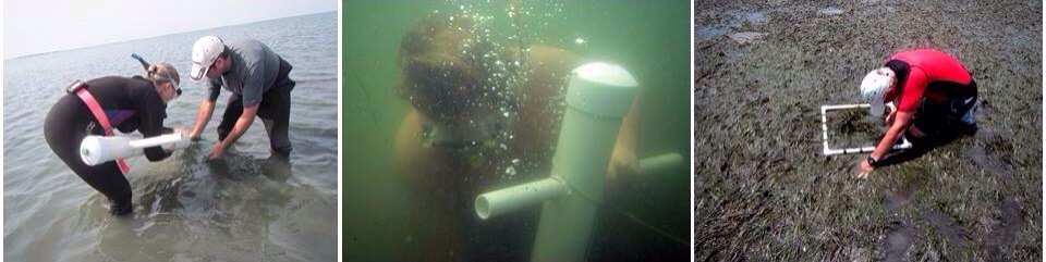
Figure 7 – Amy and Troy extract a seagrass core sample at a shallow water site (left). Core extraction is not as easy in deeper water when a mask and snorkel must be used as demonstrated by CCFHR staff Walt Rogers (middle). Don had a difficult time estimating percent cover at this particular site where the seagrass was emergent at low tide (right).

We were fortunate enough to have aerial imagery overflights by the North Carolina Department of Transportation take place during our 2013 sampling with coverage of all study sites. This imagery will be classified for seagrass using a semi-automated technique developed at our lab. The classified layers will be used to quantify differences in seagrass spatial patterns across hydrodynamic gradients and is an additional component of our research in the Albemarle-Pamlico Estuary System that seeks to quantify differences in seagrass spatial patterns across hydrodynamic gradients, identify thresholds in hydrodynamic drivers of seagrass spatial pattern, and examine how seagrass spatial pattern influences ecological resilience in the face of climate change, namely increasing severity and frequency of hurricanes.

IMG_0515.JPG
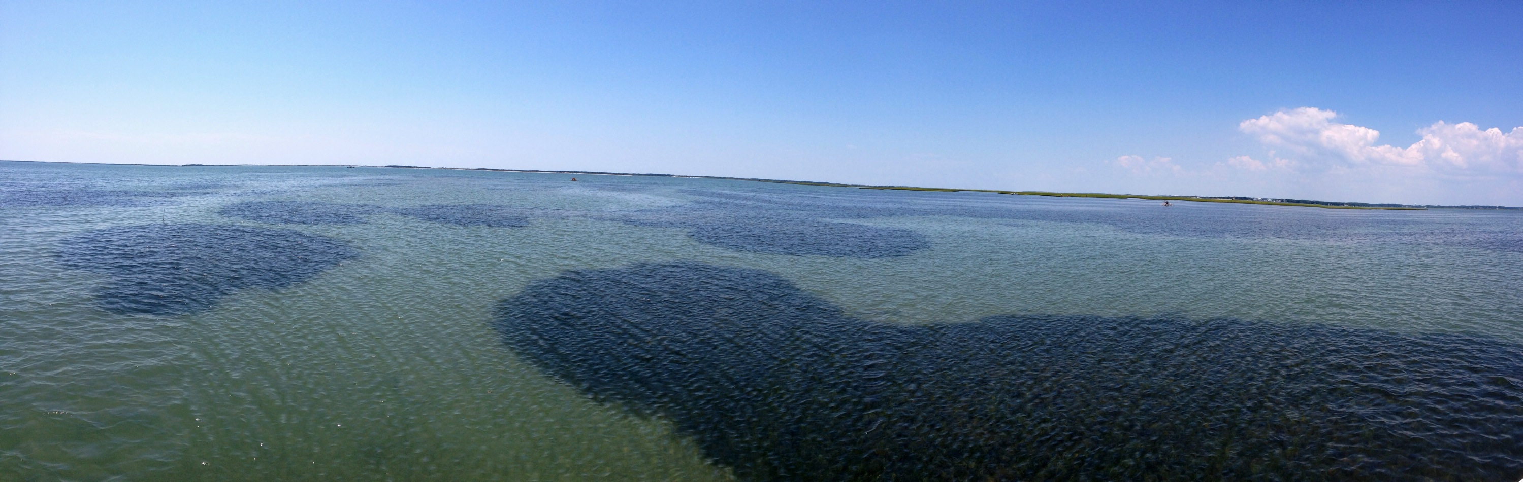
Figure 8 – A panoramic view of one of our sites located at Middle Marsh North. This site experiences intermediate levels of tidal currents and wind-wave exposure which results in a seagrass seascape of elongated patches.

Categories
Notes from the field

Notes from the field: A wee taste of Scottish seagrass

Every so often, we feature seagrass meadows from all over the world. This week, Maria Potouroglou writes about seagrass in Scotland. Maria is a PhD student at Edinburgh Napier University studying carbon sinks in seagrass. Her seagrass adventures started six years ago with projects in Greece, Spain and England.

——————————————————–

[Photos and text by Maria Potouroglou]

Hello Team,

My name is Maria and last February I started my PhD at Edinburgh Napier University looking at the role of seagrasses as coastal carbon sinks under the supervision of Prof Huxham, Dr Diele and Prof Kennedy. Many of you will wonder what a Greek does in Scotland, when seagrasses flourish in the Mediterranean! Well, UK has always been an exotic place to me, and moreover the most abundant meadows of the most widespread seagrass genus occur here, in Scotland.

Ecological fieldwork is sometimes fraught with so many obstacles that is hard to imagine why anyone would want to do it. The soft-sediment marine intertidal is one of those habitats that pose a special challenge to the species that live there and the scientists who try to study them. While the species have well adapted to the alternating physical conditions, scientists must fight the tides, which often occur too early or too late and are not sufficiently low (!!) and try to walk on the glue like sediment, which most of the times results to a cream-mud up to the knees, or fully covered waders when gravity prevails over stability.

maria_soctland_fig1

Fieldwork is carried out at Forth Estuary which is located on the east coast of Scotland and contains approximately a quarter of the population of Scotland (~1.3 million people) and a significant proportion of its industry. The Forth estuary is a macrotidal coastal plain estuary, with extensive intertidal mudflats, where Z. noltii forms sparse beds. No dedicated Zostera survey has ever been carried out in the Firth of Forth, while in Scotland’s Marine Atlas of 2011, seagrass beds in the area were completely discarded. So, last May we established ten permanent plots, which we were monitoring biweekly by recording percentage coverage, number of shoots, length of leaves, number of flowers and any signs of disease. I am glad to say that we have a nice dataset of the growth season under our belt. Moreover, we attempted to develop an image analysis technique to actually calculate percentage coverage of the quadrats, instead of relying on our subjective visual estimations.maria_soctland_fig2This technique was also used to map the seagrass meadows in the area. Finally, in late October we took a series of sediment cores, which are being analysed at the moment for total organic matter, organic carbon, and different sources and age of carbon.maria_soctland_fig3Preliminary results have been already presented at a Pecha:Kucha Event (20 slides, 20 seconds per slide – and YES that is a challenge) in Edinburgh, whereas a more detailed talk about our study will be given at the final conference of the COST Action ES0906, “Seagrass productivity: from genes to ecosystem management”, which will be held on March in Portugal.

Seagrass research in Scotland is up and running, so watch this space for more updates of our work.maria_soctland_fig4

Categories
Notes from the field

Notes from the field: Samos, Greece

Every so often we feature a seagrass meadow from around the world. This week, Richard “RJ” Lilley reports from Samos, a Greek Island in the North Aegean. He is a PhD student at the interdisciplinary Sustainable Places Research Institute at Cardiff University and is exploring seagrass links to food security. He is part of the Seagrass Ecosystem Research Group (www.seagrass.org.uk) and a founding member of Project Seagrass (www.project-seagrass.co.uk).

——————————————————————————

[Photos and text from RJ Lilley]  

Hello again Team Seagrass!

My last notes from the field were 1st June this year when I was reporting from the Turks and Caicos Islands in the Caribbean. Now I am back in Europe once more and into the field again, this time it’s Greece!

I have recently arrived on Samos, a relative small Greek Island (478 km2) located just 1.6km from the Turkish border. A great portion of the island is covered with vineyards (from which muscat wine is made) and the climate so far appears to be living up to pre-trip expectations – “mild rainy winters, and warm rainless summers”.

RJ_Greece1I am working here in collaboration with Archipelagos – Institute of Marine Conservation  exploring the ecosystem service value of seagrass meadows in the the region, and helping to propose potential future management strategies to ensure the conservation of this essential fish habitat.

RJ Greece 3I am proposing multi-method (UVCs, stereoBRUV and Fyke Netting) surveys of the meadows to study fish assemblages and I a hoping to establish some Seagrass-Watch sites across the local island group. This should be a challenge since the dominant seagrass is Posidonia oceanica and there are not as yet pre-determined protocols for this species.

RJ Greece2 I plan to remain here for 12 months and so weather and logistics permitting I should be able to generate quite a comprehensive data-set. Luckily I also have access to Wi-Fi, and so if anyone is keen to follow life in the field check out #teamseagrass or #projectseagrass on instagram for periodic photo updates from life in the field.

I’ll be in touch again with our progress, so watch this space!

RJ


For more information on Archipelagos – Institute of Marine Conservation see here – http://archipelago.gr/en/kentriki-selida-archipelagos/
For more information on the Seagrass Ecosystems Research Group see here – http://www.seagrass.org.uk
For more information on Project Seagrass see here – http://www.project-seagrass.co.uk
For more information on the Sustainable Places Research Institute see here – http://www.cardiff.ac.uk/research/sustainableplaces/
 
And for those Facebook fans out there!
https://www.facebook.com/ProjectSeagrass
https://www.facebook.com/Archipelago.gr
 
And twitter….
@ArchipelagoGr
@ProjectSeagrass
Categories
Notes from the field

Notes from the Field: All around the UK

Every so often, we feature a seagrass meadow from around the world. This week, we were lucky enough to hear from Benjamin Jones who’ll be reporting from several seagrass meadows all over the United Kingdom. Ben is an MRes student at Swansea University where he is part of the Seagrass Ecosystem Research Group (www.seagrass.org.uk) and a founding member of Project Seagrass (www.project-seagrass.co.uk).

——————————————————————

Photos & Text by Ben Jones


Over the past 6 months or so, I’ve been out and about around the UK carrying out sample collection for my research project. This involves investigating the role and use of Zostera marina as a biological indicator. The work is being carried out in fulfilment of an MRes degree at Swansea University in collaboration with the Seagrass Ecosystem Research Group.

My project is involves examining the health status of seagrass meadows over a gradient of human induced impacts, with specificity to elevated nutrients and eutrophication. Through collaborations with Seasearch divers, various wildlife trusts as well as research bodies, I have been fortunate enough to visit a number of seagrass meadows around the UK for this research. As a result, the number of locations that have been included in project has steadily risen.
Wales1

The first seagrass meadow I sampled was located at Gelliswick Bay, Wales. This allowed me to get to grips, so to speak, with my methodology, so that I could refine it for future sites. This first sample collection also gave me a bit of a test as to where the seagrass was, which I finally managed to find after an extremely low tide exposed its outer edge. With a good idea of the location and nature of this meadow, I decided to continue sampling at this site for a separate temporal study. Wales2After much red tape and requests for a licence, I was given permission to sample on the Isle of Wight in collaboration with Hampshire and Isle of Wight Wildlife trust who were carrying out mapping for their Solent Seagrass Project. However, this did involve a 3 a.m. start. The joys of working around the tides!

Wales3

With samples being collected from Gelliswick Bay, Skomer Marine Nature Reserve and Porthdinllaen in Wales, Studland Bay, Southend-on-Sea and Helford River in England, the Isle of Man, the Isles of Scilly, the Isle of Wight and Strangford Lough in Northern Ireland, I’ve tried to include as many sites along a gradient of anthropogenic impacts as possible, with Gelliswick Bay and Southend-on-Sea being at the higher end of the scale and Skomer Marine Nature Reserve and the Isles of Scilly at the lower end. Wales4

At each of the sites a number of morphological measurements were taken to assess the habitat and to form the basis of my data. These measurements were shoot density, percentage cover, leaf length, leaf width and number of leaves per shoot. By using these measurements coupled with leaf tissue C, N, N15 and P contents, which is being analysed by IBERS at Aberyswyth University, we hope that it will provide a good level of understanding into the availability of nutrients to the seagrass in the locations we have studied, and for the first time provide a quantitative understanding as to the actual, rather than perceived, risk of the seagrasses to these elevated nutrients.

The next couple of months will be spent sorting through the rest of my samples and finishing of my project, hopefully with some good results to report back with so watch this space.

Categories
Notes from the field

Notes from the Field: Turks & Caicos Islands

Every so often (but only as often as we receive contributions) we feature a seagrass meadow from around the world. This week, Richard (RJ) Lilley reports from South Caicos is the Turks and Caicos Islands. He is a PhD student at the interdisciplinary Sustainable Places Research Institute at Cardiff University. He is exploring seagrass links to food security. He is also part of the Seagrass Ecosystems Research Group which are engaged in basic and applied research into the structure, function and resilience of seagrass meadows within a linked social ecological system and the food security support these meadows provide.

—————————————————

  Photos & Text by Richard Lilley.

RJ_caicos1
(click to enlarge)

Hello #teamseagrass,

So here we are based on South Caicos, part of the Turks and Caicos Islands archipelago, working in collaboration with Department of the Environment and Maritime Affairs and the staff at the School of Field Studies. This seagrass research forms part of an interdisciplinary research project between Cardiff University’s Sustainable Places Research Institute and Swansea University’s Department of Biosciences, exploring the ecosystem service value of seagrass meadows in the the region, and helping to propose potential future management strategies to ensure the conservation of this essential fish habitat.

The Turks and Caicos Islands are a British Overseas Territory and lie southeast of the the Bahamas island chain. Whilst being geographically contiguous with the Bahamas they are separate political entities. Here in the Turks and Caicos Islands there is generally a dry and sunny marine tropical climate and but current temperatures here in June are high, averaging around 30℃ and we’ve been receiving some pretty high winds and heavy rainfalls interrupting our survey work somewhat!

RJ_caicos2
(click to enlarge)


Our survey work is multi-method. We’ve laid some Fyke-nets which we check every 12hrs at 06:00 and 18:00 and we’ve been Beach Seining at night from 20:00. Daytime visual censuses have also been undertaken.

RJ_caicos3
(click to enlarge)

Sites were chosen that represented “Lagoon” meadows and “Reef” meadows. Meadows were surveyed using a variety of techniques (visual census, fyke netting and seine netting) to triangulate data and establish robust representations of species assemblages. Species type, size and number were recorded and the data gathered elicited some important relationships between seagrass meadows and species habitat use. This was supported by data accessed and reviewed from local fisheries. Specifically key fisheries (e.g. Grouper, Conch, Grunt) in the Turks and Caicos Islands contributing to major export products and local food supply are supported by seagrass meadows.

We plan to remain here for the whole of June and so weather permitting we should be able  to generate quite a decent data-set. Luckily we also have access to Wi-Fi, and so if anyone is keen to follow our progress check out #teamseagrass on instagram for daily photo updates from life in the field.

For more information on the project see here – http://www.cardiff.ac.uk/research/sustainableplaces/news/step-forward-for-seagrasses.html

For more information on the joint collaboration see here – http://www.seagrass.org.uk

For more information on the Sustainable Places Research Institute see here – http://www.cardiff.ac.uk/research/sustainableplaces/

For more information on Swansea University Biosciences see here – http://www.swansea.ac.uk/biosci/

For more information on the School for Field Stuides see here – http://www.fieldstudies.org/tci

For more information on the Department of the Environment and Maritime Affairs see here – http://www.environment.tc

Categories
Notes from the field Uncategorized

Notes from the field: Yellow River Delta, China

Every so often (but only as often as we receive contributions) we feature a seagrass meadow from around the world. This week, Laura Soissons shares her observations of her field site in the Yellow River Delta in China. Laura is a PhD student with the Royal Netherlands Institute for Sea Research (NIOZ-Yerseke) studying human impacts on seagrass.

———————————————————

Photos & text by Laura Soissons

“Where are the seagrasses?” This is the main question my colleagues and I had in mind last summer when we were visiting our field site in the Yellow River Delta area in China. Sadly enough, we haven’t seen them make a comeback.

Seagrasses in the Yellow River Delta are the main topic of a collaborative project between the Royal Netherlands Institute for Sea Research (NIOZ-Yerseke) and the Yantai Institute for Coastal Zone Research (YIC-CAS) in China founded by the NSFC-NWO. As part of this project, my PhD research is, in a broad perspective, looking at the impact of human activities on seagrasses and how these activities can affect their resilience to environmental stresses. Our first and main focus is to understand the recent seagrass decline in the Yellow River Delta area.

And this is where the story starts…

When we first visited the area in 2011, we found a small and declining seagrass meadow southward of the Yellow river mouth, surrounded by dikes, oil platforms and salt industries. We called it: YR5.

Pumpjacks, oil platforms and salt evaporation ponds on the coastline surrounding the seagrass meadow


The meadow was composed of a single seagrass species: Zostera japonica and showed a sparse and poor distribution over the tidal flat.

One patch of the Zostera japonica meadow in May 2011 at YR5


We progressively learnt about the recent dike construction around the area that cut kilometres of the tidal flat, and thus changed the whole shape of the area. We also discovered some interesting and dominant species like the snail Bullacta exarata, which is invading the entire area and used for aquaculture. Further research on this snail showed us that it originates from Korea and arrived in the area in 2008 after being placed and cultured there by humans for food. It mainly feeds on diatoms and organic matter at the sediment surface but not on seagrasses. Nevertheless, this species is now colonizing the entire tidal flat and remains one of the last living species there (together with crabs and a few bivalves).

The snail Bullacta exarata (Philippi, 1848) at YR5


Back to the YR5 field site at the end of May 2012, we had hard times finding the seagrasses. After hours of searching we finally found some even scarcer shoots in an area surrounded by the saltmarsh plant Spartina anglica in tussocks (invasive plant in that area). Local temperatures were already high enough to think that the seagrasses were late for the growing season… And when we looked at the shoots in more details, we saw how unhealthy they were: holes in the leaves, black leaves and very weak tissues.

Left over of the seagrass meadow in May 2012 (zoom on seagrass shoots from the same place)

Two weeks after this discovery, we came back to the exact same place. We found only dead rhizomes, and just a couple of shoots left with more black leaves than before. We even felt very guilty for having been sampling a few shoots two weeks before (samples for tissue analysis, trace elements and pollutants content).

June 2012 – dead rhizomes at YR5 as the only remaining of the seagrass meadow

We observed a highly dynamic system over the summer with strong winds and waves at high tide. Sediment was getting coarser and accreting, sometimes burying the seagrass shoots. For our final visit at the end of July, no seagrasses were left. The dead rhizomes were washed away or already degraded and the hours we spent looking for seagrasses remained unsuccessful.

There are many reasons that could explain the sudden collapse of this Zostera japonica meadow at YR5. It could be the anthropogenic influence but also a combination of changing environmental variables and pollution from the Yellow River and surroundings. So far, we found no historical data reporting the existence of this meadow or anything related to the status of this particular tidal flat before the dike construction in 2009 (from what we know). Observing the seagrass meadow decline over its ‘growing season’ showed us one more time how crucial it is to take into account our long-term influence on a meadow. Stakeholders in that area will not give up on expanding their activities but also want to consider their impact and the need to preserve their environment. Within our project we want to emphasize this seagrass loss by understanding more about the reasons of their decline and how we made it happen.

Categories
Notes from the field Uncategorized

Notes from the Field: North Wales, United Kingdom

Every fortnight (or so we hope) we feature a seagrass meadow from around the world. This week, Rosemary Mc Closkey writes about her field site in Porth Dinllaen in North Wales. Rosemary is currently a Masters student at Swansea University and she is studying juvenile fish populations in Zostera marina meadows. 

——————————————————————-

Photos and text by Rosemary Mc Closkey

I am a student from Swansea University and I am currently undertaking a month of field work for my Master’s thesis, where I am studying juvenile fish populations in a Zostera marina seagrass meadow in Porth Dinllaen on the Llŷn peninsula, North Wales. My data collection has been carried out alongside and with the support of an on-going collaborative project between SEACAMS and the National Trust here in Wales.

Seagrass bed at Porth Dinllaen on low water

I first visited the site with SEACAMS at the end of April this year to assist with their fish monitoring work and to assess some scarring of the bed caused by moorings in the bay. This also allowed me to get the ‘lay of the land’ so to speak, and to design the methodology for my project. I joined SEACAMS once more in June to carry out more work and to run trials on some small fish traps designed to catch shrimp and small fish. Unfortunately these yielded very little success and as I had yet to visit this site on the low spring tides, I was keen to return for an extended period so I could get a real feel for the site and to adjust my method.  Myself and a field assistant returned to Porth Dinllaen at the start of August with a smaller, lighter seine net with a finer mesh than that which I had used with SEACAMS in April and June. These nets seem to be working successfully and selecting the age/size classes that I wanted.

My research thus far is focused on assessing sites of varying complexity and heterogeneity within the meadow in order to elucidate whether small-scale variations within the bed affects species assemblages. During the 1st week of August, low water on spring tide caused the bed to become exposed, thus allowing some assistants and myself to carry out a habitat assessment.

Carrying out habitat assessment on the Z. marina bed

Plots of 36m2 were assessed and permanently marked out using marker pegs and GPS. Detailed photographs were also taken. I was initially skeptical as to whether or not the heavy duty orange pegs I had used to mark out the plots would last, but I was pleasantly surprised to see most of them have. They have proven very useful for relocating each plot. The main working hazard in that respect has been young kids stealing them for their sandcastles!

I have fished within each of the plots using an 8m beach seine net to assess the dominant species and size classes of juvenile fish. Initially I wasn’t sure whether I would catch the same species that were caught in the much larger seine net. I have found that I am catching all the same species as before, however the majority are juveniles, small fish and shrimps. The larger, fast moving finfish and bigger predators seem to evade the smaller net! The majority of the fish caught were wrasses, gobies, dragonets, sea scorpions, plaice, sticklebacks and pollack. We have also caught the slightly more elusive species such as little cuttlefish and pipefish.

Greater pipefish (Syngnathus acus). One of the many beautiful creatures in the Porth Dinllaen seagrass bed.

I plan to stay one more week at this beautiful location to collect some more fishing data. Getting access to the site for this length of time has been a real joy and I have been very fortunate to be able to carry out extended field work of this nature for my masters project. I look forward to returning to Swansea in order to write up my results and my thesis.

For more information on The National Trust: http://www.nationaltrust.org.uk/
For more information on SEACAMS: http://www.swan.ac.uk/seacams/

Categories
Notes from the field

Notes from the Field: South Florida

22nd May is International Day for Biodiversity and the theme for 2012 is Marine Biodiversity. In celebration, we will be featuring a series of articles on seagrass. This week, Elizabeth “Z” Lacey writes about her experiences in the long-term monitoring project in the seagrass beds of South Florida under the direction of Dr. Jim Fourqurean.

—————————————

By Elizabeth “Z” Lacey

During my own Ph.D. research for the past five years, I have been doing long-term monitoring of the over 18,000 km2 of seagrass beds in south Florida as part of the ongoing research in the Fourqurean Seagrass Ecosystems Research Lab (http://www2.fiu.edu/~seagrass/).  Seagrass species present include: Manatee grass Syringodium filiforme, Turtle grassThalassia testudinum, Shoal grass Halodule wrightii, Widgeon grass Ruppia maritima, Johnson’s seagrass Halophila johnsonii, Paddle grass H. decipiens and Star grass H. englemanni.  This is a similar list to the one Brooke Landry reported during her vacation in the Bahamas in a previous blog post.  Compared to the 50-60 seagrass species possible, our diversity is relatively low.  With long-term data on seagrass density and nutrient content, Dr. Jim Fourqurean and fellow researchers are able to determine how these seagrass beds are changing over time and what these changes may indicate for overall seagrass bed health.

 FKNMS permanent seagrass monitoring sites (sites located in the Dry Tortugas are not shown).

 Long-term monitoring site Photo by N. Blinick.

 My dive buddy Kirk Gastrich and I complete a seagrass survey at one of the long-term monitoring sites.  Photo by N. Blinick.

Changes in seagrass beds will also have important impacts to the diversity of species that use them for habitat, feeding grounds, refuge and as an important corridor between mangrove and coral reef habitats.  While our seagrass diversity may be limited, there are a multitude of important fish, crustacean and other species supported within these ecosystems.  It is estimated that Florida seagrass beds provide ecological services worth over $40 billion US each year (http://www.dep.state.fl.us/coastal/news/articles/2011/1103_Seagrass.htm).  In addition to the photos of stingrays and sea turtles I posted in my other World Seagrass Association blog entry about my work in Akumal, Mexico, there are a wide diversity of animals that can be seen on any given dive in the seagrass beds of South Florida.  But rather than bore you with my prose, why don’t I let the pictures speak 1,000 words (or many thousands when it comes to the number of diverse species supported in tropical seagrass beds!).

 Caribbean Reef Squid (Sepioteuthis sepioidea). Photo by Captain K. Gastrich.

 Barracuda (Sphyraena barracuda) Photo by Z. Lacey

 Grouper, an important commercial species, spotted in the seagrass bed.  Photo by J. Sweatman

 Sea urchin using turtle and manatee grass to camouflage itself in the seagrass bed. Photo by Z. Lacey


Octopus inside a pipe positioned in the seagrass bed to hold a channel marker—you never know what you’ll find when you are observant while snorkeling in a seagrass bed! Photo by Z. Lacey

            These photos are just a few of the many, MANY species that can be found in Florida seagrass beds.  On a recent field trip with my Introduction to Marine Biology students at Florida International University, we caught other animals like moray eels, batfish and sea robins!  In honor of today being International Day for Biodiversity, I invite you to get into the water and spend some time in the seagrass beds.  If you aren’t lucky enough to live near some of these magical ecosystems, then on next vacation you have I invite you to head on down to the Florida Keys and enjoy the diversity of life that seagrass beds support.  These are the things that keep me excited about working in marine ecosystems as I prepare to defend my Ph.D. in just a few short weeks!

Categories
Notes from the field

Notes from the field: On vacation at Freeport, Grand Bahamas Island

22nd May is International Day for Biodiversity and the theme for 2012 is Marine Biodiversity. In celebration, we will be featuring a series of articles on seagrass. This week, Brooke Landry writes about her seagrass explorations while on vacation in Freeport on Grand Bahamas Island.
—————————————————

Photos and text by Brooke Landry

As a dedicated seagrass ranger, I can’t go on vacation anywhere near the ocean without treating my time there as an underwater exploratory mission. Most recently, I visited Freeport on Grand Bahamas Island, where my mother and I foolishly purchased a timeshare several years ago. One of the true pleasures of vacationing in this spot is the exquisite seagrass bed just 40 or so meters off the beach. Owning a timeshare here means that I can do a repeat sampling of sorts and I’m happy to say that I’ve seen very little change in the bed over the past six years.

The bed is composed of what you’d expect in the clear, shallow, oligotrophic waters of the Bahamas. It’s dominated by Thalassia testudinum with Halodule wrightii and Syringodium filiforme filling in some of the gaps. There’s also a good supply of macroalgae, mostly calcareous greens including Halimeda, Penicillus, and Acetabularia. The grass is fairly dense but patchy and although it’s subject to some disturbance from the rent-by-the-hour jet skis, I have seen neither an expansion nor a decline in the grass itself. What I have seen is an increased number of Diadema antillarum (yah!). Although there is very little coral interspersed in this seagrass bed, there are cinderblocks and as it so happens, long-spined sea urchins love to hide in cinderblocks. I’m assuming the blocks at one time secured buoys for the swim net or served as tie-downs for jet skis, but now there are several just randomly abandoned throughout the bed. In fact, I planned to complain to the resort management about cleaning them up until I realized they were serving as urchin refuge.

The beach with seagrass shadow in the background.

Other urchins, mostly West-Indian Sea Eggs, under the mistaken impression that they were invisible because of the dead seagrass, sponges, and random children’s toys attached to their tests, were everywhere in this particular grass bed. Literally, everywhere. It’s an interesting and beautiful sight to see.

On this most recent trip I also spotted a couple of cow-nosed rays swimming peacefully together, just a meter from unsuspecting and oblivious swimmers. This is the kind of thing I generally like to point out to people, but I’ve grown wary of doing so over the years because, as it turns out, not everyone thinks sea critters are as cool as I do. In fact, most people completely freak out at the notion of being in the water with other living things. I’ve seen swimmers go berserk because their feet touched seagrass. Grass!!! Not a spiny urchin or something that could, given the inclination, bite you, but grass! I’m not even kidding. So I chose to let them swim in oblivion and savored the grace of the rays by myself.

In addition to sting rays, octopi, and urchins that are welcome in any healthy seagrass bed in the Bahamas, I saw one not-so-welcome inhabitant: a Lionfish. Having worked with folks down in North Carolina that did extensive research on Lionfish and their invasive destruction of all things pristine, I’ve seen many Lionfish in captivity. I had never actually seen one out in the water though and it took me by surprise. It was hiding in one of the same cinderblocks that the Diadema were using. I had so many mixed feelings when I noticed it – it was almost like seeing a particularly obnoxious celebrity starlet. It was beautiful and I was awestruck, yet I sort of hated it for its indiscriminately destructive behavior. I wanted it to be gone, but really, it couldn’t help that it was born a Lionfish in the wrong place, so I also felt sorry for it. I named her Pandora and tried not to judge her too harshly, because, after all, there is no species on earth more destructive than my own.

Categories
Notes from the field

Notes from the field: Reflections from down under

22nd May is International Day for Biodiversity and the theme for 2012 is Marine Biodiversity. In celebration, we will be featuring a series of articles on seagrass. This week, Michael Durako writes about his experiences visiting North Queensland, Australia.
———————————————————-

Photos and text by Michael J. Durako  

During the Fall 2011 semester while on research reassignment from my University, I spent 5 weeks with the Marine Ecology Group (MEG), Fisheries Queensland in Cairns hosted by Dr. Robert Coles, Dr. Michael Rasheed and my former student Katie Chartrand.  During this research visit I focused on assessing changes in leaf spectral reflectance as an indication of seagrass physiological condition, specifically in response to light and desiccation stress. During my visit I was able to sample two relatively pristine sites on Green Island, which is 24 km offshore of Cairns, and several highly-impacted sites in Gladstone Harbour, which is 250 km north of Brisbane.  Before departing for Cairns I was able to assemble a field compatible spectral reflectance system to obtain spectral reflectance measurements in situ using, with the help of Randy Turner and Lance Horn at the University of North Carolina Wilmington Center for Marine Science. The system consisted of a 25m long optical fiber reflectance probe connected through a variable neutral density filter to an Ocean Optics spectrometer with data acquisition controlled by OOI Spectra Suite software via a waterproof external switch and a Panasonic Toughbook PC.

Figure 1. Ocean Optics reflectance setup at Green Island.

 After calibration and testing the reflectance measurement system at the Northern Fisheries Center in Cairns, I set up a short-term shading experiment on Green Island. Shades, which reduced irradiance by 70%, were placed over Halophila ovalis (Hov) and Thalassia hemprichii (Th) located along the inner fringe of a seagrass bed on the south side of the island. The spectral reflectance of leaves of these two species were compared between adjacent full-sun and shaded plots from 0800 to 1400h to determine if this bio-optical characteristic exhibited short-term diurnal changes in high and low light treatments. The resulting reflectance spectra showed significant species, time and treatment differences.

Figure 2. Shade plots over Halophila ovalis and Thalassia hemprichii at Green Island.

 During my visit, I was very fortunate to be able to participate in an aerial (helicopter) seagrass survey trip to Mourilyan Harbor, 80 km south of Cairns. Because of the high tidal range (4 m), turbid water and presence of saltwater crocodiles, aerial survey techniques are broadly used by MEG in their seagrass assessment work in northern Queensland. This aerial approach may be applicable and more efficient for some of our FHAP sampling sites in Florida Bay. We were able to sample 126 sites in about 2 hours and never got our feet wet!

Figure 3. Hovering (altitude 1m) at a seagrass sampling site in Mourilyan Harbor. Helen Taylor of MEG is entering the GPS location of the sampling station on an ARC GIS map using a touchscreen PC. Carissa Fairweather is communicating sampling information to the pilot. My job was to enter the seagrass data on the field datasheets.

 I visited Gladstone Harbor over Sept 27-29th as part of a compliance sampling trip for Queensland Fisheries. During this trip I compared the spectral reflectance of submerged versus exposed seagrasses at four sampling sites: Pelican North, Whiggins, Fisherman’s Island and Pelican South.  Because of the large tidal range (3-4m) and high turbidity, we could only sample during the afternoon low tides. Reflectance data indicated distinct spectra between submerged and exposed leaves for both Zostera capricorni and Halophila ovalis at all four sites (see example spectra in Fig. 6; note separation of spectra from 500-680nm).

 Figure 4. Launching the Fisheries Queensland R/V Halophila at Gladstone Harbor.

Figure 5. Sampling exposed Zostera capricorni at Pelican South, Gladstone Harbor.

 Figure 6. Normalized reflectance of submerged (wet) versus exposed (Dry) Zostera capricorni at North Pelican, Gladstone Harbor.

 Near the end of my visit, I was able to visit Green Island again. My plan was to repeat the shading study in another location on the Island.  However, because of an early occurrence of Irukandji jellyfish, which are extremely venomous, the island was closed to swimming, within an hour of my arrival on the island. One of the resort divers was stung on the lip (she had on a stinger suit) and had to be MediVaced off the island by helicopter. Thus, I had to limit my sampling to only low tide. To make lemonade from lemons, I revised my sampling to be similar to what I had done in Gladstone Harbor.  I compared the spectral reflectance of submerged and exposed Thalassia hemprichii and Halophila ovalis.  The reflectance spectra were again distinct between species and between submersed and emersed shoots, although the differences were more subtle than those at Gladstone.  The results from this short field visit suggest that spectral reflectance provides a rapid assessment method that is sensitive to changes in seagrass physiological condition and it provides another tool in our arsenal of non-invasive physiological ecoindicators.

Figure 7. Measuring spectral reflectance of exposed Halophila ovalis at Green Island.